


Sponsored: Rupert Bidwell, vice president for insurance solutions at ICEYE, talks to Insurance Times about the power of leveraging satellite technology
1. How would you describe the evolving nature of the flood threat in the UK?
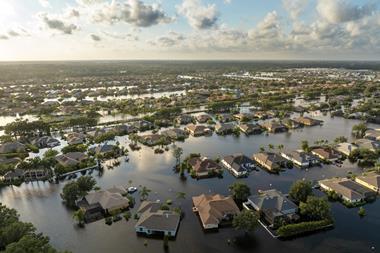
Over 5.5m UK properties are exposed to flood risk – and climate change will increase this.

The government spends £2bn a year on flood protection maintaining extensive flood defence networks, yet these are increasingly being breached.
During Storm Babet for example, while thousands of properties were protected, well over 2,000 properties were still inundated – many in locations previously flooded.
We’ve seen major surge defence erected since the 2013 winter floods, but a recent study by the Gallagher Research Centre and HR Wallingford puts 60,000 properties still at surge risk – rising to 77,000 by 2050.
The country certainly benefits from high levels of flood insurance penetration – over 90% according to Defra.
It has a robust insurance market underpinned by Flood Re which wrote 265,826.policies in 2022/23. Yet this backstop is temporary and, as studies predict increasing flood exposure due to a warming climate and rising sea levels, insurers will increasingly have to take the strain.
2. What do you see as some of the main bottlenecks for the insurance sector when managing flood events?
In addition to the overall size of flood-related losses – which the ABI puts at around £700m a year – a key issue for insurers is the surge in claims activity from major flood events.
If you look at the impact of Storms Dudley, Eunice and Franklin in 2022, the market handled almost 180,000 storm and flood claims over successive weeks and months.
Managing these surges puts huge pressure on the sector, straining resources and significantly increasing claims resolution periods.
If a flood lasts for over 24 hours, according to Flood Re, the average processing of a claim increases by about 100 days. That’s a very long wait for policyholders, creates significant insurer backlogs and can be reputationally damaging.
3. How can the use of flood data from satellites support a more effective response to these surge event?
Earth observation data can enhance every phase of the response. There are two key aspects – the granularity of the data available and the speed at which it can be accessed.
Synthetic aperture radar (SAR) satellite imagery provides detailed images of floods as they develop. At ICEYE, we have built and operate over 30 SAR satellites orbiting earth capturing images day or night and, more importantly given the peril, through clouds.
We combine this imagery with ground-level data, including river gauges, topography data and sensors, to create high-resolution information showing not only extent but flood depth in centimetres at the individual property.
We’re collecting this data as the event develops and multiple times during the flood lifecycle.
Operating our own constellation means we can enable detailed loss analysis almost instantly – in the case of Storm Babet insurers were receiving our flood analysis within 24 hours of its peak. That level and speed of insight puts insurers in a much stronger position to respond proactively to support policyholders and reduce the financial impact of the event.
4. How are insurers using this data?
The data can be applied at every stage. It is made available in an actionable format sent either directly to insurers or accessed via geospatial platforms. Insurers can overlay the flood information with property portfolio data to get an instant understanding of the policyholder impact.
This puts them in a much stronger position to respond. By knowing which properties have been impacted, proactive communications to policyholders can begin the claims process immediately.
Having accurate flood inundation data for each building also significantly improves claims triaging and, in turn, speeds up claims resolution.
It also means companies can maximise the value of their supply chain – and ensure their adjusters, drying companies and builders are mobilised and directed earlier, as well as the early securing of temporary accommodation for impacted customers.
We believe satellite-based earth observation data can play a key role in boosting insurers’ ability to respond to surge events – not only supporting more effective response capabilities but also amplifying the value of insurance and market reputation through improved overall performance.