


Model will now consider new flood defence schemes
RSA has improved its Geographical Risk Assessment (GRA) model to include over 100 updated features and take into account newly constructed flood defence schemes.
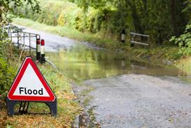
The GRA tool, which was launched in 2002, is used to assess the risk of arson, crime, flooding and subsidence. The tool provides a risk score for each peril at an individual property level. The GRA system grades all properties into one of five risk categories from negligible through to extreme for each peril.
The Environment Agency continues to invest in improving flood defences thereby reducing the risk of flooding that many properties face. RSA said has updated its GRA tool to reflect these changes and is now able to provide a more accurate price to its customers
Rob Osment, GRA manager at RSA, said, “Our tool has long been considered in the industry as a highly effective and innovative way of assessing risk and the recent changes ensure we are up to date with geographical developments.
"By using the new model we will continue to be able to compete for new business more effectively in areas where other insurers will find it difficult to be as selective.”


No comments yet